
 Current academic consensus holds that the French settlement of Fort Caroline was located on the St. Johns River in modern-day Jacksonville, Florida. Yet details in both French and Spanish written accounts as well as details in drawings left behind by the colony’s resident artist, Jacques Le Moyne, have always contradicted this location. These accounts suggest the colony was built 80 miles north of the St. Johns River on the Altamaha River in modern-day Darien, Georgia. Instead of taking the French at their word, academics have instead dismissed their accounts as fanciful and riddled with errors. But when the correct location of Fort Caroline is accepted these “errors” become, instead, accurate eyewitness accounts of real places and people and thus an important documentation of the people and culture of ancient America.
In this post I will look at the evidence for where Fort Caroline was located. I will present evidence which supports both the St. Johns River and the Altamaha River as being the proper location.
The Written Accounts
The best place to start is with the actual French accounts of where their fort was located. According to their written accounts it was located on the River of May. Le Moyne notes,
“A long way from the place where our fort was built there are high mountains, called the Apalatci in the Indian language, where…three large streams rise and wash down silt in which a lot of gold, silver and copper is mixed. They put it in canoes and transport it down a great river, which we named the River of May and which flows to the sea.”
Clearly the St. Johns River does not flow from the Appalachian Mountains to the sea thus it can’t possibly be the River of May, the location of Fort Caroline. Nor are there any mountains with gold in Florida at the headwaters of the St. Johns River. The closest river that flows from any mountains would be the Altamaha River which lays some 85 miles north of Jacksonville, Florida at Darien, Georgia. In fact, the closest gold deposits to Darien, Georgia lay just southwest of Athens, Georgia along the Apalachee River, a river which is connected to the Altamaha by way of the Oconee. The Apalachee River flows into the Oconee River which flows into the Altamaha River. If the Altamaha is the May River then gold deposits exist in the exact area where the French said they did.
View Altamaha Gold Deposits in Georgia in a larger map
These latter could then form settlements, raise cattle, and give assistance to numbers of vessels which are lost on the coast of the province of Satoriva, at or near St. Augustine, San Matheo, where the French Lutherans established a fort for the purpose of plundering all vessels that arrive from the mainland, whether from Mexico, Peru, or any other country. They have already done this thing, and taken refuge on the San Matheo river, where dwell in villages the perfidious chiefs, SATORIVA, ALIMACANY.
San Matheo was the name that academics believe was given to the St. Johns River by the Spanish. This appears to be validated by a description of the San Mateo River given by Fontaneda later in his narrative:
On the banks of the San Matheo, sixty leagues further inland, reside other independent chiefs, CARDECHA, ENCAPPE, UTINA, SARANAY, and MOLOA, who govern other villages reaching as far as Mayajuaca, in the Ais country, near the district planted with reeds, which our guides said was the place where Don PEDRO DE MENENDEZ made terms of peace with them.
Mayajuaca is shown on old maps as existing in Central Florida on the St. Johns River. The Ais were a tribe also known to live in this area. Thus the San Matheo does appear to be the St. Johns River. Then he makes some nonsensical statements:
In ascending the river San Matheo, one can go as far as Tocobaga on the west side of Florida, but I do not advise any one to go so far as this river. After having passed the bar of the river, one might go on as far as Agacay, which is fifty or sixty leagues from the coast, or even as far as Utina, where he could disembark and proceed from village to village until, arriving at Canogacola, the inhabitants of which are subjects of TOCO-BAGA. Thence he could go on to the very farthest known point, situated on another great river [Mississippi], whither DE SOTO went, and where he died.
The St. Johns River comes nowhere near the west side of Florida. Yes, one could conceivably disembark at the western-most point of the St. Johns River in downtown Jacksonville and then travel overland the 350 miles to Pensacola or the 550 miles to the Mississippi River at New Orleans but why? The St. Johns in no way makes this travel any easier. It’s not like the St. Johns takes one to the west coast of Florida as this narrative suggests. Also, at no point does the St. Johns travel westward “fifty or sixty leagues from the coast, or even [further.]” A Spanish league equals approximately 2.6 miles thus this suggests a distance between 130-160 miles. The St. Johns reaches its westernmost point in downtown Jacksonville, Florida before turning south, a distance of around 15 miles from the coast. And along its entire length it is never more than 25 miles from the coast. Even its westernmost tributary, the Ocklawaha River, doesn’t exceed 70 miles from the east coast of Florida.
Of course, his distances could have been meant to be measured from the coast at the mouth of the St. Johns River. This seems to be the case in a second translation of his narrative:
By way of this River San Mateo, one may go to Tocobaga, on the other side of Florida, to the west; I do not mean all the way by the river, but in this manner: Enter over the bar of the San Mateo, and arrive at Zaravay, which is fifty or sixty leagues in the interior up the river, or at the Province of Utina, and there disembark, keeping a westerly course from town to town, until coming upon the people of Cafiogacola, subjects of Tocobaga; and thence upon the country of Tocobaga itself, which lies within on another large river, where Soto was, and where he died .
Yet “fifty or sixty leagues” or 130-160 miles “upriver” on the St. John’s would take a traveller towards Orlando, Florida. Why would one travel south to central Florida in order to travel west to reach the Mississippi River?
The route from Jacksonville to Orlando. View Larger Map
This portion of the narrative simply doesn’t make since if Fontaneda is referring to the St. Johns River. Thus what river was Fontaneda describing? Could he also have been describing the Altamaha?
The Altamaha reaches its westernmost point via its tributary, the Ocmulgee River, near present-day Jacksonville, Georgia (not to be confused with Jacksonville, Florida)– a distance of around 130 miles from Darien, Georgia. The coast is another ten miles east of Darien bringing the total distance to 140 miles. This is much closer to Fontaneda’s “fifty or sixty leagues from the coast.”
Fontaneda also mentioned that the Native American province of Utina was at this location. The Spanish built a mission to the Utina in the 1600s called the Mission Santa Isabel de Utinahica. The site of this mission is believed to be along the Altamaha/Ocmulgee River somewhere near Jacksonville, Georgia. The 1625 map, created just 55 years after the founding of Fort Caroline, also placed the Utina in this location. Thus this seems to confirm that the Altamaha was the river Fontaneda referred to as the San Mateo. One could certainly disembark at the Altamaha/Ocmulgee’s westernmost point known as the Big Bend and then travel west towards the Chattahoochee (or Mississippi.) Disembarking in Orlando and travelling west in hopes of an overland route to the Chattahoochee or Mississippi would serve absolutely no purpose.
The route from Darien, Georgia to Jacksonville, Georgia. View Larger Map
The 1737 map even shows that the river was now named San Juan, i.e., St. Johns, it’s current name– not San Mateo. More importantly, the 1625 map shows the “River de May” was located north of this Fort San Mateo near where the Altamaha is located today. This seems to confirm that the May River was one-in-the-same as the Altamaha River which was also once referred to as San Mateo when Fort San Matheo was located there. Apparently after Fort San Mateo was relocated to the St. John’s River the Spanish renamed the Altamaha the Santa Isabel River.
This evidence suggests a new interpretation of the previously mentioned passage from Fontaneda’s account which I stated seemed to support the St. Johns as the San Mateo:
On the banks of the San Matheo, sixty leagues further inland, reside other independent chiefs, CARDECHA, ENCAPPE, UTINA, SARANAY, and MOLOA, who govern other villages reaching as far as Mayajuaca, in the Ais country, near the district planted with reeds, which our guides said was the place where Don PEDRO DE MENENDEZ made terms of peace with them.
This can now be interpreted as meaning that Utina and these other chiefs along the San Mateo/Altamaha River governed “other villages reaching as far as Mayajuaca, in the Ais country.” In other words, Fontaneda wasn’t suggesting that the San Mateo river itself flowed into this territory but that the chiefs along the San Mateo/Altamaha River “governed” villages reaching far into central Florida. Since we know the Timucua language family was spoken among tribes throughout this entire region it becomes quite possible that Timucua-speaking tribes on the Altamaha had satellite villages throughout this area as far south as central Florida. This likely explains why De Soto encountered villages named Utinamocharra and Uriutina when he marched through Florida. This also makes all of Fontaneda’s commentary consistent with the geography of the region and the known location of tribal provinces such as the Utina and further supports the Altamaha being the San Mateo/May River and not the St. Johns.
It should be remembered that Fontaneda lived in La Florida for seventeen years and published his accounts just ten years after the fall of Fort Caroline. If anyone was familiar with its true location and the geography and rivers of La Florida it would be him. And his accounts only make sense if the San Mateo was, in fact, the Altamaha. Likewise, the French accounts only make sense if the May River was the Altamaha.
Also, there is a strong likelihood that Fontaneda actually visited Fort Caroline. Le Moyne includes in his accounts an episode where he has two Spanish castaways living among the Indians brought to the fort. They stated they had been shipwrecked in the domain of the Calusa fifteen years earlier. This is consistent with Fontenada’s history in La Florida. Thus one of these men could easily have been Fontaneda thereby explaining how he would have known the location of Fort Caroline.
The Menendez Account
The only problem that arises from Fort Caroline being located in Darien, Georgia is its distance from St. Augustine. According to Pedro Menendez, the Spanish general who captured Fort Caroline, it was only 12-15 leagues from St. Augustine which is between 31-39 miles. This is almost the precise distance between modern St. Augustine, Florida and Jacksonville, Florida.
Yet today’s St. Augustine may not be the location of the first fortification of that name built by the Spanish. It is known that the first fort called St. Augustine was soon burned by local Timucua Indians and a new site for the fort had to be found that was further from this tribe. According to the French accounts the Spanish landed near a Native American village called Seloy and then marched north to Fort Caroline. The 1625 map shows Seloy as being located north of the Cape of Francaise, today’s Amelia Island, Florida. Based on this map Seloy was located north of the River of Dolphins which was either the St. Marys or Satilla River. Based on the size of the river depicted on this map it appears to be the Satilla River which is a much broader river than the St. Marys. On this map the River of Dolphins is shown similar in size to the Altamaha which is the only other river depicted in this area of the map even though other rivers larger than the St. Marys such as the Turtle River are located there. Since the Turtle River isn’t depicted it’s unlikely a small river like the St. Marys would be depicted. Plus the St. Marys River turns almost due south for quite a distance before returning north. No such southerly turn is shown for the River of Dolphins. This strongly suggests the River of Dolphins is the Satilla River. This would place Seloy on the north side of the Satilla River across from modern-day Woodbine, Georgia which is a distance of around 37 miles south of Darien. This is the same distance Pedro Menendez estimated was between St. Augustine and Fort Caroline.
Another detail from Menendez’s account supports this new location for the original Fort St. Augustine. Apparently a tropical storm or hurricane was approaching the area and luckily for the Spanish the high winds had blown the French reinforcements of Fort Caroline (led by Jean Ribault) out to sea. Menendez decided to take advantage of this French misfortune and march overland to launch a surprise attack on the undefended fort. According to Menendez it took him three days to reach Fort Caroline because of the numerous rivers in the area which were swollen with rain water and too deep to cross so they had to take a circuitous route in order to find places to cross these streams:
Not knowing the way, we hoped to get there in two days, it being distant about eight leagues or so, as we were told by two Indians who went with us as guides. Leaving this Fort of St. Augustine in the order above described and with determination on the eighteenth of September, we found the rivers so swollen from the copious rains that it was impossible to ford them and we were obliged, to take a circuitous route which had never been used before through swamp and unknown roads to avoid the rivers.
After walking until nine or ten o’clock at night, on the morning of the twentieth, which is the feast of San Mateo, we arrived in sight of the Fort.
An analysis of the route from modern St. Augustine to Jacksonville, Florida shows no such rivers. Only a few creeks exist along the most direct route between these two sites, none of which are substantial enough to have required much of a detour in order to get around them. Only Pablo Creek along this route may have required a detour.
An almost direct overland route exists between St. Augustine and Jacksonville. View Pedro Menendez Florida Route to Ft. Caroline in a larger map
But no such easy coastal route exists between Woodbine, Georgia and Darien, Georgia. The only possible route would be to go inland. And in this area between the Satilla and the Altamaha rivers many such rivers exist that would have required a “circuitous route” in order to get around them.
View Menendez Georgia Route to Ft. Caroline in a larger map
Yet Menendez’s descriptions of the San Mateo River seems to describe both the St. Johns River and the Altamaha as well as neither of them. It is unclear what his information is based on. He notes:
The River San Mateo, running by the Fort we captured, goes seventy leagues inland and turns to the southeast emptying into the bay of Juan Ponce, …On this river are three large Indian towns… This Port is 29 1/2 degrees, and the San Mateo which we captured is 31 degrees. The French and their pilots were mistaken. I have had it taken by the sun on land. From here to the Cape of Canaveral there are fifty leagues, three rivers, two ports; between here and Havana, one hundred leagues, more or less, which are navigable in boats among the keys of Canaveral and Los Martyres, and from there to Havana.
Menendez’s description that the river “goes seventy leagues inland and turns to the southeast emptying into the bay of Juan Ponce” describes neither the Altamaha nor the St. Johns River. Traditionally, the Bay of Juan Ponce is shown on old maps in southwest Florida. Yet this doesn’t seem to be the same location that Menendez referred to as the Bay of Juan Ponce. In another letter, Menendez described the Bay of Juan Ponce this way:
“I now ask that 300 may be here in the sourse of April…for the settling of the Bay of Juan Ponce, for the river of the fort of St. Matthew which we took from the enemy goes 60 leagues inland within this Bay, and by means of this river we shall easily communicate from one sea to the other. The multitude of Indians there are there will be thus sooner brought to the knowledge of our Holy Catholic Faith, for, in this Bay of Juan Ponce, is the province of Apalache an indomitable people, with whom the Spaniards have never been able to effect anything and as this province is level, we can easily pass over as far as New Gallicia, which may be about 300 leagues distant about as far to Vera Cruz, and about as much farther to Honduras and to Yucatan.”
It’s clear from the passage above that the Bay of Juan Ponce referred to by Menendez was not the one in southwest Florida but instead was located in northwest Florida which is where the “province of Apalache” was located. His Bay of Juan Ponce was either Apalachee Bay or Appalachicola Bay. The fact that a 1562 map by Diego Gutierrez showed the Chattahoochee River named the Rio de Juan Ponce further suggests that Menendez’s Bay of Juan Ponce was Appalachicola Bay. The fact that Menendez mentioned that this province was flat and made it easy to pass overland to New Gallicia and onto Vera Cruz, located on the Gulf Coast of Mexico, further confirms he is discussing northwest, not southwest, Florida.
His knowledge of this river seems to come directly from Fontaneda. Fontaneda’s account of the River San Matteo on which Fort Caroline was located is consistent only with the Altamaha River not the St. John’s River. Apparently Menendez believed that when traveling west from the coast up the Altamaha/Ocmulgee River system that when it turned south at the Big Bend area it continued on to the Chattahoochee and ultimately to the Appalachicola Bay- his “Bay of Juan Ponce.” (Of course, it doesn’t. It loops back north and heads towards Macon, Georgia instead.) Menendez apparently misunderstood Fontaneda’s account just as many researchers have over the years when all Fontaneda was trying to convey was that one could travel west on the Altamaha/Ocmulgee River towards the Chattahoochee but you must depart the river in the Province of Utina (the Big Bend region) and travel overland, from one Indian village to the next, before you reached it and once you reached it you could take it to the coast and into the land of the Apalachee and islands of Tocabago.
Now it becomes clear that Menendez was also talking about the Altamaha River and not the St. John’s River as the location of Fort Caroline/San Matteo. But then he makes more confusing comments when he states that there are “three rivers and two ports” between “here” [St. Augustine] and Cape Canaveral. But there are definitely not “three rivers” and “two ports” between modern-day St. Augustine and Cape Canaveral. Matanzas Inlet near St. Augustine and Ponce Inlet near New Smyrna Beach are the only “rivers” or “ports” between these two locations. But there are, indeed, three rivers and two ports between the Satilla River in Woodbine, Georgia and Cape Canaveral: the St. Mary’s River, Nassau River and St. Johns River plus the two “ports” of St. Augustine Inlet and Ponce Inlet. (Apparently Matanzas Inlet wasn’t counted as a port. Even today no development has occurred on this inlet suggesting it doesn’t possess the qualities necessary for a port.) Once again, Menendez’s seemingly confused statements only make sense if Fort Caroline was on the Altamaha River and the original Fort St. Augustine was on the Satilla River.
A French survivor of the attack, Le Moyne, noted that the Spanish were constructing their fort five or six leagues south of Fort Caroline. He also noted that when they went to find the Spanish it took them only two hours of sailing to find them. If the original Fort Caroline was really on the St. Johns River then this suggests the original Fort St. Augustine was no further south than Ponte Vedra. If this was so then Menendez’s account of overflowing rivers makes even less sense. Yet six leagues south of Darien, Georgia would place the Spanish a little south of Brunswick. This location would still require the Spanish to find routes around the Turtle River and Little Turtle River which are both substantial rivers– wide and deep. Once again this account only makes sense if Fort Caroline was located on the Altamaha not the St. Johns.
One year after its construction the local Timucuan tribe burned the original Fort St. Augustine and it was relocated. Perhaps it was relocated to a friendly village at the modern Fountain of Youth site in St. Augustine which archaeologists have confused as the original location of the fort.
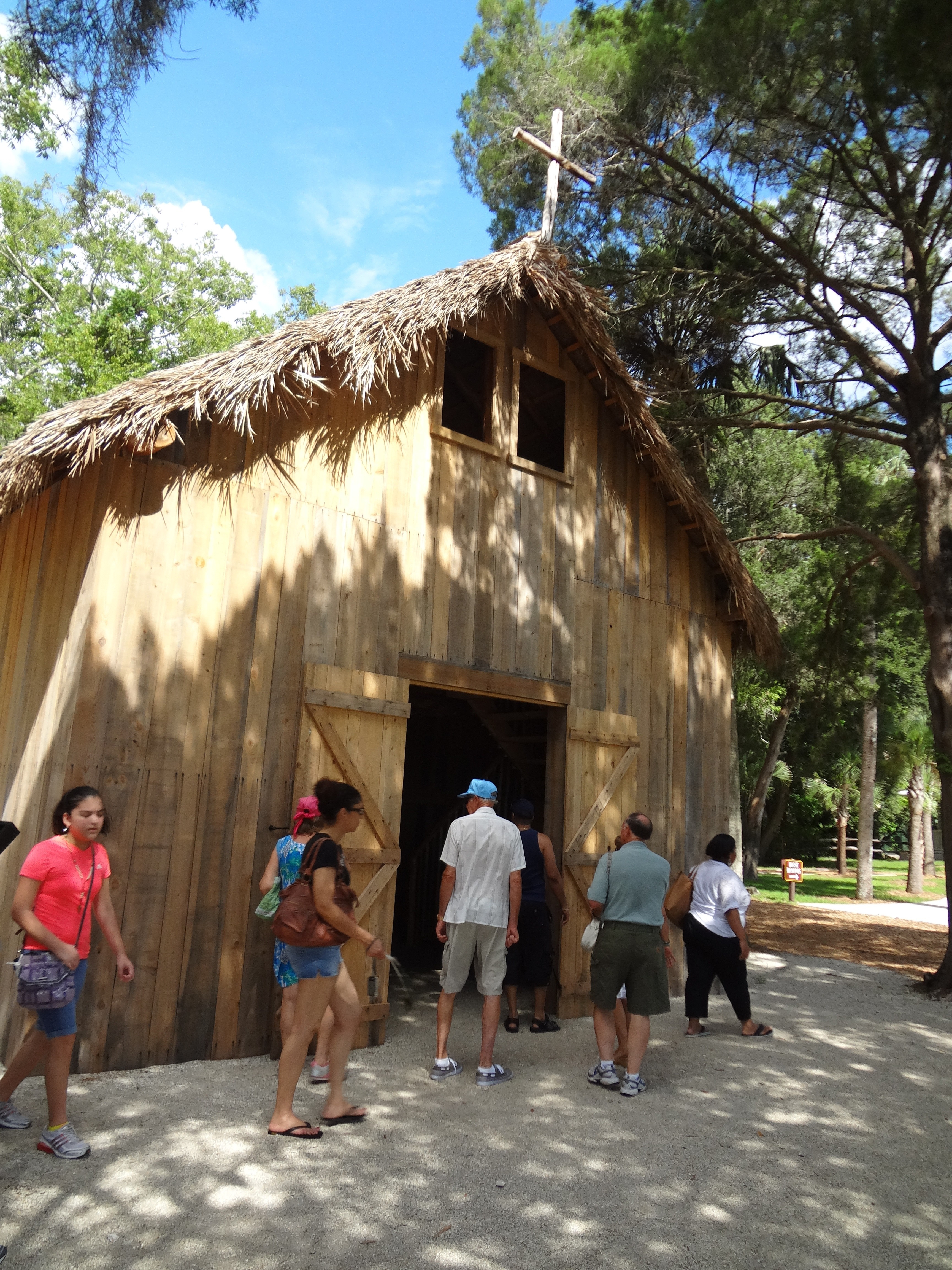
Recreated Spanish chapel at the Fountain of Youth site in St. Augustine, Florida. (c)2013 Gary Daniels
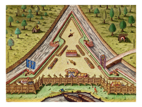
Le Moyne’s Paintings
Another clue about the true location of Fort Caroline is contained in the paintings of Fort Caroline’s resident artist. Academics have long asserted that these paintings contain errors such as mountains in the background when no such geology exists in Florida.
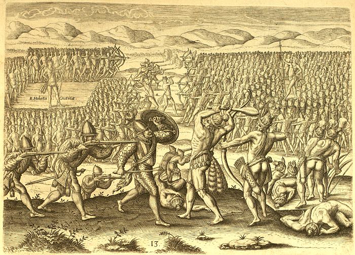 This image illustrates a battle between the Utina and Potano which the French took part in. According to Le Moyne they traveled up the River of May to reach Utina’s village. This village was said to be on the way to the lands of the Potano who were said to be mining gold near the mountains of Apalatci. All of these details only make sense when one realizes the River of May was the Altamaha River in Georgia not the St. Johns River in Florida. The Potano lived in the shadow of the Appalachian Mountains, not in the swamps of Florida, just as the painting depicts. (A tribe called the Potani did live near modern Ocala, Florida and were likely related to Georgia’s Potano. Just like with the Utina it appears the Potano had satellite villages in Florida which has caused all manner of confusion among Florida anthropologists.)
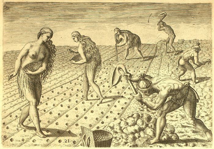 Another “error” in Le Moyne’s paintings claimed by academics is one showing Native Americans planting crops in rows. Academics assert that this was not a practice of Native Americans in Florida. Yet apparently these academics are unaware of the archaeological evidence found at the Corn Field Mound at the Ocmulgee Mounds site, so-called because the mound was built over an old corn field that preserved precisely this type of row cropping. Coincidentally, this site existed in Macon, Georgia along the Ocmulgee River, a tributary of the Altamaha River– the exact area where Le Moyne claimed to have witnessed such practices.
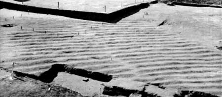
The Corn Field Mound excavated at the Ocmulgee Mounds site in Macon, Georgia revealed that natives did plant crops in rows.
These agricultural rows unearthed at the Ocmulgee Mounds site in the 1930s are proof that Native Americans in Georgia did, in fact, use row cropping and that Le Moyne’s depictions were not fanciful but an accurate eyewitness account.
Rediscovery of Fort Caroline?
If Fort Caroline/Fort San Mateo was, indeed, located on the Altamaha River near Darien, Georgia then it is likely that its ruins were the basis for an account (recently rediscovered by researcher Marilyn Rae) by English naturalist William Bartram when he visited Darien in 1776. Bartram noted:
…it assumes the name Alatamaha, when it becomes a large majestic river, flowing with gentle windings through a vast plain forest, near an hundred miles, and enters the Atlantic by several mouths. The north channel, or entrance, glides by the heights of Darien, on the east bank, about ten miles above the bar, and, running from thence with several turnings, enters the ocean between Sapello and Wolf islands. The south channel, which is esteemed the largest and deepest, after its separation from the north, descends gently, winding by M`Intosh’s and Broughton islands; and lastly, by the west coast of St. Simon’s island, enters the ocean, through St. Simon’s Sound, between the south end of the island of that name and the north end of Jekyl Island. On the west banks of the south channel, ten or twelve miles above its mouth, and nearly opposite Darien, are to be seen, the remains of an ancient fort, or fortification; it is now a regular tetragon terrace, about four feet high, with bastions at each angle; the area may contain about an acre of ground, but the fosse which surrounded it is nearly filled up. There are large Live Oaks, Pines, and other trees, growing upon it, and in the old fields adjoining. It is supposed to have been the work of the French or Spaniards. A large swamp lies betwixt it and the river, and a considerable creek runs close by the works, and enters the river through the swamp, a small distance above Broughton Island.
Only two known forts were built near Darien: Fort King George (1721-1736 ) and Bachelor’s Redoubt (1736-1748.) The locations of both of these forts are known: Fort King George is on the mainland near Darien and Bachelor’s Redoubt was in Brunswick, Georgia in what is today a subdivision called the Marshes of McKay. Neither of these locations match the location described by Bartram. Furthermore, these British forts had only been abandoned for between 30-40 years when Bartram visited Darien thus it seems certain the locals would have retained a memory that they were British forts not “the work of the French or Spaniards.”
Unfortunately, a map from the 1780’s created shortly after Bartram’s visit is torn away and missing exactly at the location of Broughton’s Island mentioned in Bartram’s account thus is unable to provide any more clarity as to the location of these ancient ruins. No other fort besides Fort Caroline/Fort San Mateo is known to have been built anywhere near this location. The fact that the ruins of the fort were in the shape of a “tetragon,” or four-sided structure, is consistent with accounts that the Spanish rebuilt the triangular Fort Caroline into a rectangular shape. The fact that “large Live Oaks” were growing on these ruins suggest they were at least 100-200 years old which is consistent with the time period that Fort Caroline was constructed.
Conclusions
Asserting that the River of May was one-in-the-same as the St. John’s River has caused academics to completely dismiss written and visual accounts of the region’s Native American inhabitants. But which is more likely: that all the written and visual accounts are in error or that modern interpretations of those accounts are in error? It is highly unlikely the French would confuse the St. Johns River which flows north from central Florida to the coast with the Altamaha which flows south from the Appalachian Mountains to the coast. It is also highly unlikely that Fontaneda would forget where this fort was located a mere ten years after having visited it. But in order to force Fort Caroline to be located on the St. Johns River it requires a complete dismissal of these written eyewitness accounts. The fact that not a single artifact has been found after years of archaeological investigations along the St. Johns River should suggest to these researchers that perhaps they are looking in the wrong place. And if the remains that Bartram saw near Darien are, in fact, the remains of Fort Caroline they should still be there today and easy enough to find and test.
[…] of Rene de Laudoneire which created the first European colony in the New World at Fort Caroline possibly in modern-day Jacksonville, Florida (or Darien, Georgia.) This colony predates St. Augustine in […]
[…] found proving the fort ever existed there or anywhere along that waterway. As I argued here and here, the overwhelming evidence supports that the fort was located somewhere on the Altamaha River not […]
[…] near Darien, Georgia and not the St. Johns River near Jacksonville, Florida (as I argued here and here) then this presents a question: where was the original Fort St. Augustine? According to the Spanish […]