
 The French claimed that their colony of La Caroline (Fort Caroline) was built along the banks of a river they named the River of May. Thus finding this river is the first task one must undertake to locate Fort Caroline and the many Native American villages they interacted with.
The River of May was first discovered and named by French explorer Jean Ribault on his first Voyage to La Florida. Jean Ribault’s account of his first trip to La Florida entitled “The True Discoverie of Terra Florrida” includes many geographical clues that help pinpoint locations that would be helpful in finding the true location of Fort Caroline. This article will apply these clues to the four river systems that have been conjectured to be the May River– the St. John’s, St. Mary’s, Satilla and Altamaha– and see how well they match up in hopes of discovering which, if any, of these rivers is the River of May.
Clue #1: Cape Francois
Ribault noted that he first sighted land and cast anchor at the end of April 1562:
“Thursday the last of Aprill at the breke of the daye we discovered and clearly perceived a faire cost, streching of a gret length, covered with an infenite number of highe and fayre trees, we being not past 7 or 8 leagues from the shore, the countrye seming unto us plain, without any shewe of hills, and approaching nearer within 4 or 5 leagues of the land, we cast ancre at ten fadom water, the bottom of the sea being plain with much oosef and of fast hold.”
Ribault then gave the first French name to a geographical feature in Florida: Cape Francois. He noted this feature was located “under” or south of latitude 29 degrees:
“On the south side as far as a certain point or cape, situated under the latitude of 29 degrees and a half, which we have named the cape Francoys, we could spy neither river nor baye, wherefore we sent our boats, furnished with men of experience, to sound and know the coast nere the shore, who returning age unto us about one of the clock at after none, declared that they had found, amonges other things, vii fadom water at the harde bancke of the sea.”
29 degrees and a half would be around modern-day Flagler Beach thus the cape Ribault named Cape Francois seems to match Cape Canaveral. Yet the fact they could “spy neither river nor bay” suggests they were further south than this since Ponce Inlet is due south of Flagler Beach. Ribault’s description more accurately fits modern day Canaveral National Seashore which is an unbroken stretch of white sandy beaches until one reaches Cape Canaveral.
View Ribault’s Dicovery of La Florida in a larger map
Clue #2: An Unbroken Coast
Ribault next noted they pulled anchors and sailed along the coast until sunset without seeing a single river or port:
“Wherupon, having dilligently wayed up our ancres and hoist up saile, Off with wynd at will we sailed and veewed the coast all along with an inspeakeable pleasure of the oderiferous smell and bewtye of the same. And bicause there apeared unto us no sign of any porte, abowt the setting of the sonne, we cast ancre agayn, which don, we did behold to and fro the goodly order of the woodes wherwith God hathe decked everywhere the said land.”
Since they previously noted it was “one of the clock at after none” (1 o’clock after noon) this means they sailed for approximately six hours since the sun sets around 7 PM in late April. But then they spotted a river and set sail again since they still had some daylight left:
“Then perceving towardes the northe a leaping and breking of the water, as a streme falling owt of the lande unto the sea, forthewith we sett agayn up saile to duble the same while it was yet daye. And as we had so don, and passed byonde yt, there apeared unto us a faire enter [ye] of a great river, which caused us to cast ancre agen and tary there nere the lande, to thende that the next mornyng|| we myght see what it was. And though that the wynd blewe for a tyme vehemently to the shore warde, yet the hold and auncordge is so good there, that one cable and one ancre held us fast withowt driving or slyding.”
If they started at Cape Canaveral then the first river or port north of there would be Ponce Inlet near New Smyrna Beach, 49 miles north. Taking a different approach, we can try to calculate how far Ribault could have sailed in the time he had. We know Ribault left the Cape Francois area sometime after 1 PM and travelled until sunset or 7 PM (6 hours). The prevailing winds along the Florida coast in April blow from east to west at between 6-14 knots. One knot per hour equals 1.151 miles per hour. Thus Ribault could have travelled between 6.9-16.11 mph or a distance between 41-97 miles in 6 hours. Since Ponce Inlet is 49 miles to the north of Cape Canaveral it is likely the river he claimed to have seen.
View Ribault’s Dicovery of La Florida in a larger map
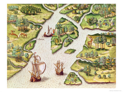
“The next daye in the morninge, being the first of Maye, we assaied to enter this porte with two rowe barges and a boate well trymed, finding little water at the entry and many surges and brekinges of the water which might have astuned and caused us to retourn backe to shippborde, if God had not speedely brought us in, where fynding fourthwith 5 or 6 fadom water, entered in to a goodly and great river, which as we went we found to increse still in depth and lardgnes, boylling and roring through the multytute of all sortes of fishes. Thus entered we perceved a good numbre of the Indians, inhabytantes there, coming alonge the sandes and seebanck somewhate nere unto us, withowt any taken of feare or dowbte, shewing unto us the easiest landing place, and thereupon we geving them also on our parte tokens of assuraunce and frendelynes, fourthewith one of the best of apparance amonges them, brother unto one of there kinges or governours, comaunded one of the Indians to enter into the water, and to approche our boates, to showe us the easiest landing place. We seeing this, withowt any more dowbting or difficulty, landed…After that we had tarried in this northe side of the river the most parte of the daye, which river we have called by the name of the river of Maye, for that we discovered the same the first day of that mounthe, congratulated and made alyance and entered into amytie with them, and presented theire kinge and his brethern with gownes of blewe clothe garnished with yellowe flowers de luce, yt semed they were sorry for our departure, “
Yet current scholarly consensus places the River of May much further north than Ponce Inlet at one of the four following rivers: St. Johns River, St. Marys River, Satilla River or the Altamaha River. Thus Ponce Inlet cannot be the River of May. This means we must reevaluate the location where the French first anchored off the coast of Florida.
View Ribault’s Unbroken Coast in a larger map
The next stretch of unbroken coast stretches from Ponce Inlet to Matanzas Inlet, a distance of 47 miles. Another stretch of unbroken coast exists from St. Augustine Inlet to the St. John’s River, a distance of 34 miles. The northernmost stretch of unbroken coast in Florida runs from Nassau Sound to the St. Mary’s River, a distance of 13 miles.
In Georgia, Cumberland Island provides the southernmost stretch of unbroken coast running from the St. Mary’s River in the south to the Satilla River in the north, a distance of 17 miles. Jekyll Island provides the next stretch of unbroken coast running from the Satilla River in the south to St. Simon’s Sound in the north, a distance of 7.7 miles.
As can be seen from this analysis, the only stretch of unbroken coast that contains a prominent cape is the one centered at Cape Canaveral which runs from Sebastian Inlet in the south to Ponce Inlet in the north. This also fits Ribault’s latitude reading the best. Yet nothing else about this location fits Ribault’s description. Thus the only conclusion one can draw is that Ribault simply forgot some of the details of his voyage when writing his memoirs while imprisoned in the Tower of London.
The St. John’s River Hypothesis
The French description of an unbroken coast with neither rivers nor ports more accurately describes Florida than Georgia. The fact that to the north of this unbroken coast they discovered a river with a shallow mouth that became deeper further on more accurately describes the unbroken shoreline north of modern-day St. Augustine and the St. John’s River. But this location exists between 30-30.4 degrees not below 29 and a half degrees as Ribault claimed. Thus Ribault’s initial calculation of the latitude of his first anchorage must have been faulty.
The only cape south of the St. John’s River area is Cape Francis at St. Augustine Inlet. Could Cape Francis be Ribault’s Cape Francois? If Ribault’s Cape Francois was really Cape Canaveral then he would have certainly seen multiple inlets or ports between there and the St. John’s River. Nor could he have travelled from Cape Canaveral to the St. John’s River in six hours no matter how great the winds were blowing.
Yet if Cape Francis is Ribault’s Cape Francois then it lies the correct distance (~32 miles) south of the St. John’s River. But it is certainly not located “below” 29 and 1/2 degrees. It is located below 30 degrees at 29.9 degrees. And St. Augustine inlet lies at this location thus contradicting Ribault’s account that they “spied neither river nor bay.”
View Ribault’s Dicovery of La Florida in a larger map
Clue #3: A Small Hill
According to Ribault’s account they set up a pillar on a small hill on the south side of the River of May claiming the land for the King of France:
“The next day in the morning we retourned to land agayne, accompaned with the captayns, gen- tilmen, souldiers, and others of our smaie troup, earring with us a piller or colume of hard stone, our kinges armes graven therin, to plaint and sett [the same] at the entrye of the porte in some high place wher yt might be easelly sene. And being come thither bifore the Indyans were as- sembled, we espied on the southe side of the river a place verry fyt for that purpose upon a littell hill compassed with cipers, bayes, palmes, and other trees, and swete pleasaunt smelling shrubs…”
The south side of many rivers in the region have high bluffs thus the “small hill” upon which Ribault placed his monument was likely such a bluff. According to historians, St. John’s Bluff was the likely location where Ribault placed his monument. Yet as we’ve just seen the St. John’s River doesn’t seem like a good fit.
View Ribault’s Dicovery of La Florida in a larger map
Clue #4: A Sand Bar
Ribault later gave additional information about the River of May describing a sand bar that prevented his large ships from entering the river:
“The night now approaching we were fain to return to our ships, much to our grief, for that we doth not hazard to enter with our ships by reason of a bar of sand that was at [the] entrance of the port, although at a full sea (high tide) there is two fathom and a half of water at the most, and it is but a leap or surge to passe this bar, not passing the length of two cables, and henceforth with every where within vj or vij fathom water, so that it maketh a very faire haven and ships of a mean burden from iiij xx to c. tonnes may enter therein at all flodes, yea, of a far greater burden if there were Frenchmen dwelling there that might scour the entrance as they do in France, and where nothing is lacking for the life of man.”
An English fathom is equal to six feet thus according to the above account the mouth of the River of May was no deeper than two fathoms and a half, or 15 feet, at high tide. Once past the sandbar the river was six or seven fathoms which equals 36-42 feet. Even today after dredging the St. Johns River is no deeper than 40 feet thus this clue seems to disqualify the St. John’s River as a candidate. (Or perhaps a French fathom was significantly different than an English fathom.)
Ribault further described the location of the May River:
“The situation is under the elevation of 30 degrees, a good climate, healthful, of good temperance…”
This creates a problem because the St. Johns River is not located “under…30 degrees” but above. Thirty degrees is just north of St. Augustine. The St. Johns River lies at 30.4 degrees thus it is “above” 30 degrees. The inlet at St. Augustine lies just under 30 degrees at 29.9 degrees. Thus this passage seems to suggest the River of May was the inlet at St. Augustine but that doesn’t seem plausible.
View Ribault’s Dicovery of La Florida in a larger map
“The next day being the third day of May, desiring always to find out harborage to rest in, we set up sail again, and after we had ranged the coast as near the shore as we could, there appeared unto us about vii leagues on this side the river of May, a great opening or bay of some fair river, whither with one of our boats we rowed and there found an entrance almost like unto that of the river of May, and within the same as great a depth and as large, dividing itself into many sea arms, great and broad, stretching towards the high land, with many other less that divide the country into fair and great lands and a great number of small and fair meadows.”
Seven leagues equals about 20 miles. The St. Mary’s River lies about 21 miles north of the St. John’s River thus if the St. John’s was, indeed, the May River then the next river Ribault discovered was the St. Mary’s. The description of the river as “dividing itself into many sea arms…with many others less that divide the country into fair and great lands…” perfectly describes the St. Mary’s River and all the rivers along Georgia’s coast.
View Ribault’s Dicovery of La Florida in a larger map
“This is the land of Chicoref whereof some have written, and which many have gone about to find, for the great riches they perceived by some Indians to be found there…We departed from them very friendly and with there contentation, but the flood and the night overtaking us, we were constrained to lie in our boats all [that] night, till it was day, Sitting upon this river which we have called Seyne, because at the entrance it is as broad as from Havre de Grace unto Honefleu.”
Ribault claimed they named this river the Seyne because it’s mouth was as wide as the Seine River in France. The Seine in France between Le Havre and Honfleur has a width of 2 miles but the mouth of the St. Mary’s is only 3,000 feet wide. This certainly doesn’t even remotely match.
View Seine River in France in a larger map
“we sailed to know more and more of the coast, going as near the shore as we could. And as we had sailed so all along about six or seven leagues, there appeared unto us another bay where we cast anchor…”
The distance of six or seven leagues equals between 17.4-20.3 miles. This would have brought Ribault to the Satilla River. Ribault noted:
“In the morrow we went thither, and finding by our sounding at the entrance many banks and beatynges, we durst not venture to enter there with our great ships, we having named this river Some, which within is a league over and of viii, ix, x, and xi fathom depth, dividing itself into many great rivers, that sever the country into many faire and great islands and small goodly medow ground and pastures, and every where such abundance of fish as is incredible.”
From this we learn that the French named this river the Somme. Ribault also noted:
“And on the west northwest side there is a great river that cometh from the high country, of a great league over, and on the other on the northeast side which return into the sea. So that (my lord) it is a country full of havens, rivers and islands of such fruitfulness as cannot with tongue be expressed.”
It is unclear which rivers Ribault was referring to since none of the rivers that empty into the Satilla or St. Andrews Sound flow from northern Georgia, i.e., the “high country.” The closest river system that flows from northern Georgia is the Altamaha River.
View Ribault’s Dicovery of La Florida in a larger map
“And besides these, we discovered and found also seven rivers more, as great and as good, cutting and dividing the land into fair and great islands…. as to the fourth the name of Loire, to the fifth Charent, to the sixth Garone, to the seventh River Belle, to the eighth Riviere Grande, to the ninth Porte Royall, to the tenth Belle a Veoir.”
The only of these rivers that is known is the ninth: Porte Royall. It is today’s Port Royal Sound at Parris Island, South Carolina. Going backwards from this known river suggests that the eighth river, Riviere Grande, must be one-and-the-same as the Savannah River. The Ogeechee River likely corresponds to the seventh river, River Belle. Garone would then be the same as the Medway River at St. Catherines Sound. Charent would be the Altamaha River and the Loire would be Turtle River at St. Simons Sound.
View Ribault’s Dicovery of La Florida in a larger map
Problems
As we can see there are multiple problems with the St. John’s River hypothesis:
- The location of Cape Francois matches the geography of neither Cape Canaveral or Cape Francis
- The location and depth of the St. John’s does not match Ribault’s descriptions.
- The mouth of the St. Mary’s River is not the same width as the Seine in France as Ribault suggests.
- The Satilla River does not have any nearby rivers that flow from the highlands of north Georgia as Ribault asserts.
The St. Mary’s River Hypothesis
If Cape Francois was Cape Canaveral then the St. Mary’s River is too far north to be the May River. As noted previously, Ribault claimed he sailed for six hours along an unbroken coast when he discovered the May River, the first river north of Cape Francois. There are many rivers and ports between Cape Canaveral and the St. Marys which further excludes it as a possibility if Cape Francois was Cape Canaveral.
If Cape Francois was the northern tip of Amelia Island then this also presents a problem because this is also where the mouth of the St. Mary’s River lies. Ribault would not have needed to sail for six hours to discover a river if Cape Francois was located on Amelia Island.
There is also no great stretch of unbroken coast south of the St. Mary’s River. As stated previously, we know that the River of May was a six hour journey north from Cape Francois covering a distance between 41-97 miles. Yet just 14 miles south of the St. Mary’s River lies Nassau Sound and a further six miles south of there lies the St. John’s River. This would seem to eliminate the possibility that the St. Mary’s River is Ribault’s River of May.
Ignoring these problems let’s next compare the rivers north of the St. Mary’s to Ribault’s list of rivers he encountered north of the River of May. He noted that 7 leagues or 20 miles north of here he encountered a river he named the Seine because it’s mouth was the same width as the Seine in France. The Seine’s mouth is 2 miles wide. Does such a river exist 20 miles north of the St. Mary’s? The Satilla River is 20 miles north of the St. Mary’s and it’s mouth is currently 2.5 miles wide thus this seems to match Ribault’s description.
The next river Ribault encountered was a distance of six or seven leagues or between 17.4-20.3 miles north of here. This would have brought Ribault to the Altamaha River, 22 miles north of the Satilla. Yet he would have passed St. Simon’s Sound which is less than 10 miles north of the Satilla River, the next largest body of water and certainly not a feature Ribault would have ignored. He would have also passed Hampton River located an additional 7 miles north between St. Simons Island and Sea Island. This seems to again negate the St. Mary’s as Ribault’s River of May.
Problems
As we can see there are multiple problems with the St. Mary’s River hypothesis:
- The location of the St. Mary’s River doesn’t match Ribault’s description whether Cape Francois was Cape Canaveral, Cape Francis or Amelia Island
- The rivers north of the St. Mary’s do not fit the distances or descriptions given by Ribault.
The Satilla River Hypothesis
If Cape Francois was modern Amelia Island then the only unbroken shore north of here would be that of Cumberland Island. Cumberland is 17.5 miles long and its eastern, ocean-facing side is one long unbroken white-sand beach. This matches Ribault’s claim that where he first sighted land was an unbroken coastline without either rivers or bays.
View Satilla Hypothesis in a larger map
Ribault next claimed he sailed 7 leagues or 20 miles north and discovered another river which he named the Seine because its mouth was as wide as the Seine River in France (2 miles wide.) Twenty miles north of the Satilla is the Altamaha River. The entrance to the Altamaha Sound is 2 miles wide thus it fits Ribault’s description. His description that this river had many arms that divided the land into many islands also fits the geography of this region. His assertion that the river flowed from the high country is also consistent with the Altamaha River which, via its tributaries the Ohoopee, Oconee and Ocmulgee, does, indeed, flow from the high country of north Georgia.
View Satilla Hypothesis in a larger map
“On the west northwest side there is a great river that cometh from the high country, of a great league over, and on the other on the northeast side which return into the sea.”
The closest river to this location that “cometh from the high country” is the Ogeechee River. But the Ogeechee is 21 miles north of Sapelo Sound. Thus this presents a problem for the Satilla hypothesis. It is possible that since Ribault didn’t give a precise distance for this river he simply couldn’t remember and actually meant the Ossabaw Sound and not the Sapelo Sound. His description of a river which flowed from the high country (Ogeechee River) and a river which returned to the sea (Vernon to Bull River system) would describe the Ossabaw Sound perfectly.
View Satilla Hypothesis in a larger map
- Loire River = Ogeechee River
- Charent River = Savannah River
- Garone River = Calibogue Sound
- River Belle = Colleton River
- Riviere Grande = Broad River
- Porte Royal e= Port Royal Sound and/or Beaufort River
- Belle a Veoir = Edisto River
If Ribault meant that Ossabaw Sound was his Somme River then the Savannah River would be his Loire, Calibogue Sound his Garone.
Problems
As can be seen the Satilla River hypothesis has several problems:
- The St. Marys River exists between the unbroken coast of Cumberland Island and Cape Francois/Amelia Island which contradicts Ribault’s claim that he spied neither river nor bay in this area
- Cape Francois/Amelia Island is not located “under” 29 degrees but above at 30.7 degrees
- The Satilla River is not located “under” 30 degrees as Ribault asserted but “over” at 31 degrees
- Sapelo Sound does not contain any rivers that flow from the “high country” as Ribault asserted
The Altamaha River Hypothesis
The preceding three analyses were based on a literal interpretation of Ribault’s writings. But it must be remembered that Ribault likely wrote his account while sitting in the Tower of London on a charge of treason. It is unlikely he had his maps and journals with him while in prison and likely relied on memory to locate the various rivers.
As noted here and here, it is likely that the River of May was one-in-the-same as the Altamaha River in Georgia and not the St. John’s River in Florida. If we start with this assumption, what modern-day rivers would correspond to those named by Ribault in the preceding passages?
Ribault noted the next river they explored was seven leagues “on this side” of the River of May. Most likely he meant “north of” which, if starting at the Altamaha, would take one to Sapelo Sound. Ribault noted that they named this the Seine River because it’s mouth was as wide as the mouth of the Seine between Le Havre and Honfleur. As noted previously the mouth of the Seine between these two locations is about 2 miles wide. As can be seen on the Google map below, the mouth of Sapelo Sound is also two miles wide.
View Ribault’s Rivers in a larger map
View Ribault’s Rivers in a larger map
View Ribault’s Rivers in a larger map
Analysis
As we can see there are multiple problems with the preceding scenario:
- The location of Cape Francois along an unbroken coast does not match Amelia Island
- The rivers immediately north of Amelia Island/Cape Francois do not match Ribault’s accounts
- But if we start at the Altamaha River then Ribault’s account matches the rivers between Darien, Georgia and Port Royal, South Carolina very well.
Conclusion
Based on Ribault’s description of arriving at Florida near 29 and 1/2 degree latitude north of a cape and finding an unbroken coastline with no rivers or inlets, it seems clear that he arrived somewhere in the vicinity of Cape Canaveral. Yet his description of the rivers he next encountered better match those in Georgia than Florida. If the River of May was the St. Johns River then the descriptions of the next rivers he encountered do not match modern geographical features. But if the River of May was the Altamaha River then Ribault’s descriptions match up very well.
The other French and Spanish eyewitness accounts of Fort Caroline’s location seem to match Ribault’s account if the River of May was the Altamaha River. But if the River of May was the St. John’s River then none of these other eyewitness accounts match with the geography of that river.
As with most documents and maps surrounding the location of Fort Caroline, nothing is crystal clear and only future archaeological work will solve this puzzle.