
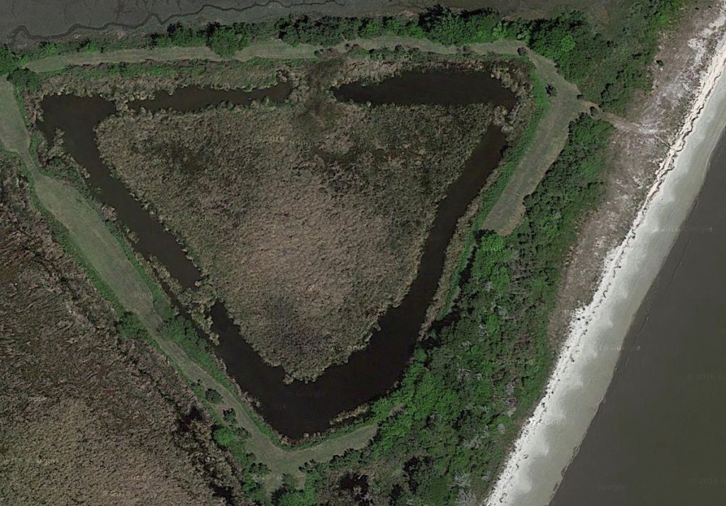
Satellite view of triangular moat on Raccoon Key
If the French fort of La Caroline was actually on the Altamaha River in Georgia and not the St. John’s River in Florida then from where did the Spanish launch their assault on the fort? Clearly this attack could not have been launched from modern-day St. Augustine, Florida because the distances involved are too great for a two-day march as recorded by Spanish General Pedro Menendez. As I argued in my article “Original Fort St. Augustine Found in Coastal Georgia?” it is clear from the eyewitness accounts that the Spanish originally constructed an entrenchment on an island and later a more substantial fort on the mainland. I suggested this fort was located near Indian mounds in the Lampedocia area of Camden County and the encampment/entrenchments was located on nearby Raccoon Key in St. Andrews Sound. I will now look at the evidence that supports Raccoon Key as the location for these original Spanish entrenchments.
7 Requirements for the Location of the Spanish Entrenchments
Here are the 7 requirements for the location of the entrenchments from where Menendez launched his march to Fort Caroline:
- The entrenchments were on a riverbank at an Indian village named Seloy and included moats, trenches and a fortified council house.
- The entrenchments were 1.5 leagues (3.9 miles) from the mouth of the harbor and activities there were visible to nearby ships.
- The entrenchments were on an island.
- The entrenchments were 8 leagues south of Fort Caroline by sea and six leagues south by land and accessible to the River of May by an inland waterway.
- The entrenchments were sixty leagues (156 miles) north of Cape Canaveral.
- There were six rivers that were deep enough they had to be swum between the entrenchments and Fort Caroline. One such river was very close to the entrenchments.
- The entrenchments were not the same location as the fort.
Here’s the evidence that supports these 7 requirements and supports Raccoon Key as the site of the entrenchments:
1. The entrenchments were on a riverbank at an Indian village named Seloy and included moats, trenches and a fortified council house.
“They went ashore and were well-received by the Indians, who gave them a very large house of a cacique which is on the riverbank. And then Captains Patiño and San Vicente, with strong industry and diligence, ordered a ditch and moat made around the house, with a rampart of earth and fagots…” (Grajales, p. 6)
–This shows that the entrenchments were at the site of an Indian village located on a riverbank. It also shows that this village had a very large council house and that a ditch and moat were dug around this house and an earthen wall (rampart) supported by wooden posts was also constructed around this council house. A triangular moat exists on Raccoon Key within which exists a circular discoloration consistent in size to a large Native American council house. The entire site is surrounded by earthworks/levees. (See my Google Map “Spanish Fortifications on Raccoon Key” below. Zoom in or out to see other details.)
“[The Spaniards] went on shore at the River of Seloy, which we had called the River of Dolphins. [Jean Ribault] had been informed by King Emola, one of our neighbors arriving during our consultations, that the Spaniards had gone ashore in great numbers and had seized the houses of Seloy and used them for their Negroes whom they had brought to do labor. He said that they now lodged themselves on the land and had made protective trenches around themselves” (Laudonniere, pp. 158-159)
–This shows that the Indian village was named Seloy and that the village area was used to house Spanish slaves and that “protective trenches” had been dug around the site. At Raccoon Key trenches are located around the council house site and the entire village site as well as within the village area. This also shows that the entrenchments were close enough that they could be seen by nearby French ships.
“Then he inspected the site chosen for the entrenchments. Within three days he had directed the unloading of everything in the ships. The two largest he had to send to Hispaniola, because they could not enter the harbor owing to their size and would be taken by the Lutherans if they remained outside.” (Barrientos, p.44)
–This shows that the large galleons (including the San Pelayo) could not enter the harbor so they were anchored outside. I suspect they were anchored in an area called “The Hole” off the northern tip of Cumberland Island. It’s the deepest location closest to St. Andrews Sound.
“He had seen to the unloading of the ships in the fastest possible time in anticipation of what later actually came to pass. So quickly was the work done that, at the end of two days and a half, despite the vessels being anchored a league and a half from the point of disembarkation, all the artillery, men, munitions, and a large part of the provision had been landed.” (Barrientos, p.44)
–This gives the precise distance between where the ships were anchored and the ‘point of disembarkation’; i.e., the entrenchments. 1.5 leagues equals 3.9 miles. This is the exact distance between Raccoon Key and The Hole (about 3.98 miles. Zoom out on the map above to see these details.).
3. The entrenchments were on an island.
“Menendez finished the work of dispatching these ships, then he put aboard a hundred-ton shallop the one hundred and fifty soldiers taken from the galliass and the other vessel sent to Hispaniola. He himself boarded a large boat, took his leave of the party bound for the island, and went to anchor on the St. Augustine bar.”(Barrientos, p.45)
–This shows that the 150 soldiers were bound for an island. I believe this is Raccoon Key. Menendez went to anchor on the St. Augustine bar which I believe is Raccoon Key Spit.
4. The entrenchments were 8 leagues south of Fort Caroline by sea and six leagues south by land and accessible to the River of May by an inland waterway.
“All the troops being now on board, a fair wind for an hour or two was all that was needed to bring us up with the enemy…” (Moyne, p.17 )
–This shows that the Spanish entrenchments were very close, no more than an hour or two sailing from Fort Caroline.
“I [Menendez] decided to turn back to the Bahama Channel to look for a harbor where I could land near them, and eight leagues from that harbor by sea and six by land, I found one which I had reconnoitered before, on St. Augustine’s Day, being about twenty nine and a half degrees. There, on the sixth, I landed 200 soldiers, and on the 7th, three small vessels went in with the other 300, and the married men with their wives and children…” (Letters, p.421)
–If Fort Caroline was on the Altamaha then eight Spanish leagues (20.8 miles) south of there would be the southern end of Jekyll Island which is where Raccoon Key is located. If Fort Caroline was on the St. John’s River then eight leagues south of there is modern Ponte Vedra Beach which is not an island nor does it have a harbor or riverbank.
“Many Indians were present, many of them chiefs, who showed themselves to be very friendly to us, and appear to us to be hostile to the French. They told us that, inside this harbor, and without going to sea, we could come to the river where the Frenchmen were, in front of their fort, by going up the river seven or eight leagues…”(Letters, p.421)
–The Indians claimed Fort Caroline was 7-8 leagues (18.2 – 20.8 miles) north via an intracoastal waterway. This is the exact straight line distance between Raccoon Key and Buttermilk Sound on the south branch of the Altamaha River via the intracoastal waterway. Buttermilk Sound is, in fact, east or “in front of” the likely location of Fort Caroline on the south bank of the south channel of the Altamaha.
“M. DE Ribault, — Yesterday at four, p.m., a Spanish fleet of eight ships hove in sight, six of which cast anchor near us. Seeing that they were Spaniards, we cut cables, and made sail; and they immediately made sail in chase, and pursued us all night, firing many guns at us. Finding, however, that they could not come up with us, they have made a landing five or six [leagues] below, putting on shore a great number of negroes, with spades and mattocks. On this state of facts, please to act as you shall see fit.” (Cossette in Moyne, p. 16)
–The French also placed the Spanish entrenchment six French leagues (17.4 miles) south of Fort Caroline. All of these accounts are consistent with the distance of Raccoon Key from the Altamaha River.
5. The entrenchments were sixty leagues (156 miles) north of Cape Canaveral.
“A strong and contrary wind blew out of the north, with such force that the Lutheran fleet was driven away. It was hurled along the coast for a distance of sixty leagues, all the way to Cape Canaveral…” (Barrientos, pp. 45-46)
“…and the storm continuing, they were driven to the north some fifty miles from the fort, where they were all wrecked on some rocks, and destroyed. All the ships’ companies were, however, saved…” (Moyne, p.17)
—-Sixty Spanish leagues is 156 miles. Fifty French leagues is 145 miles. (*Note: It’s likely le Moyne meant ‘south’ not ‘north’ and the translator meant ‘leagues’ not ‘miles.’) Modern St. Augustine is only 104 miles north of Cape Canaveral. Raccoon Key is 180 miles north of Cape Canaveral but I think the French fortified encampment they constructed after their shipwreck was north of the actual cape near Turtle Mound since Menendez claimed the French ran to a “mountain” when they saw him:
“the Frenchmen seeing us, were afraid of us, and abandoning the fort, took to flight to the mountain…” (Letters, p.440)
According to Amos W. Butler in his article “Observations on some shell-mounds of the eastern coast of Florida” there were once 22 Indian mounds along the coast between Daytona Beach and Cape Canaveral. The tallest of these was Turtle Mound, a fifty feet tall shell mound. It and another named Castle Windy were the closest to Cape Canaveral. Butler noted that Turtle Mound and the somewhat smaller Green Mound “were regarded by mariners, in the day before light-houses, as the most conspicuous landmarks on the eastern coast of Florida.” (Butler, p.107) Turtle Mound is approximately 145 miles south of Raccoon Key and Castle Windy is 152 miles south of Raccoon Key. Modern St. Augustine is only 109 miles from Cape Canaveral and 71 miles from Turtle Mound thus Raccoon Key fits these distance estimates better than modern St. Augustine.
“The Adelantado was at Fort St. Augustine when some friendly Indians came to report that a number of men, similar to those he had slain, were building a fort and a ship at Cape Canaveral, which is eight days’ march to the south, inside the Bahama Channel, but north of the Head of the Martyrs.” (Barrientos, p.70)
–The Head of the Martyrs is shown on old maps as the Florida Keys. So this passage shows the French had crashed north of the Keys at Cape Canaveral. This is consistent with it being near Turtle Mound or Castle Windy mound. According to Menendez, his men could average 8 leagues (20.8 miles) a day marching in difficult terrain:
“Every day they forged ahead at least eight leagues, and what is most unbelievable, did so across a countryside which was difficult throughout, and covered with sandy stretches….”(Barrientos, p.72)
–We know they were marching down the beach towards Cape Canaveral (since Spanish boats were following them just offshore) thus there would have been no major obstacles. 156 miles divided by 8 days equals 19.5 miles per day which is consistent with Menendez’s claim of 20.8 miles per day. If they started from modern day St. Augustine, 104 miles to the north of Cape Canaveral, they would have averaged only 13 miles a day in very easy terrain. Worse still, Turtle Mound is only 71 miles south of St. Augustine thus they would have averaged only 8.8 miles a day to reach this location. This seems to negate the possibility that modern St. Augustine was the site of the entrenchments.
6. There were six rivers that were deep enough they had to be swum between the entrenchments and Fort Caroline. One such river was very close to the entrenchments.
“They had brought no boats, and before reaching Fort Caroline they had to swim more than six rivers.” (Barrientos, p.50)
–There are not six rivers between St. Augustine and the St. John’s River (see map above) thus this refutes the claim that these were the locations of the Spanish entrenchment and French fort. There are, indeed, six rivers between Raccoon Key and the Altamaha River site of Fort Caroline.
“When the party first set forth from the fort at St. Augustine they had at once encountered a river they hesitated to cross. The Adelantado, to set the example for his men,as a good captain ought, swam across first, with his pike in his hand. The others immediately followed, for as good soldiers they felt it would be a disgrace not to do what their captain, clothed and armed, had done.” (Barrientos, p.50)
–This reveals that there was a river very close to the entrenchments. This matches the Raccoon Key location (see map above) which would require the soldiers to cross a river in the marsh before reaching dry land at Dover Bluff. The Fountain of Youth site where archaeologists believe the original entrenchments were located does have a nearby river but there was no need to swim across it since their Indian guides would have surely led them down their trails which correspond to A1A & US1 which heads north towards Jacksonville with no need to cross this river. In fact there is an all land route between St. Augustine and St. John’s Bluff in Jacksonville with only one major creek, Pablo Creek, which would have needed to be crossed.
7. The entrenchments were not the same location as the fort.
“As soon as he had landed he sent out three hundred soldiers to reconnoiter and find the most suitable place to dig trenches for protection during the interval in which the location of the fort was decided.” (Barrientos, p. 44)
“As soon as he reached there [the harbor of St. Augustine] he landed about 300 soldiers and sent two captains with them, who were to reconnoiter that daybreak the next morning the lay of the land and the places which seemed to them strongest (for defense), in order that they might dig a trench quickly while it was being seen where they could build a fort…” (Méras, p. 89)
“When I shall go on shore, we shall look out a more suitable place to fortify ourselves in, as it is not fit where we now are.” (Letters, p.423)
–These accounts show that the site of the entrenchments was not the same as the fort which was constructed one month later. The French came upon the Spanish while they were digging their entrenchments which could be seen from the French ships. This shows the entrenchments were near the ocean. When the French were struck by the hurricane Menendez began his march to Fort Caroline. There was no time to build a fort and the only thing the Spanish had constructed up to that point were the entrenchments. The Spanish marched to Fort Caroline between September 18-20. The plans for the fort weren’t drawn up until October 23-26:
“They reached St. Augustine on October 23. Before setting out, Menendez….advised them of the method he wished them to follow with regard to…building the fort, whose plan he had drawn up…On the morning of October 26 he took his leave…” (Barrientos, p.70, 71)
–After Indians burned the original fort it was moved to the harbor entrance:
“Menendez reached St. Augustine on May 18 [1566]….After meeting with his captains, the decision was reached to move the fort to the harbor entrance. There the Indians would be unable to do them so much damage and the Spaniards, at that site, would also be in a better position to prevent the entrance of enemy ships…On the next day a party went out to the sand bar at the harbor entrance, and there drew up plans for a fort. Its construction was undertaken with energy.” (Barrientos, p.108)
–This shows that the fort was upriver and not near the harbor entrance yet the entrenchments were close enough to the harbor entrance that their activities could be seen by nearby French ships. Thus the fort and entrenchments have to be in different locations. Since Raccoon Key is near the harbor entrance it must be the location of the entrenchments. Later the fort was moved to the harbor entrance, i.e. Raccoon Key. Thus the entrenchments site became the location of the second fort (or third fort if you count the entrenchments as the first fort.) Later, after more Indian attacks and a mutiny by soldiers, the fort was moved to modern-day St. Augustine, Florida and blockhouses were built at both the site of the entrenchments and the old fort site:
“Still another blockhouse, similar to the one at Polican, was to be erected in Soloy, the district of Cacique Soloy…Construction of this last mentioned post was to be undertaken by the end of July, 1567. Three leagues outside of San Mateo, in the village of Saturiba which the Adelantado had visited, Gonzalo de Villaroel was to build yet another blockhouse and there station some soldiers. Other outposts were planned on a height overlooking the residence of Cacique Alimacani, and at old St. Augustine.” (Barrientos, pp. 134-135)
–This shows that the Indian village of Soloy/Seloy, the site of the entrenchments, was different than “old St. Augustine,” the site of the first fort (likely at the Lampedocia site) which was abandoned in May 1566. This also shows that a blockhouse was planned to be built on Raccoon Key after the fort there was abandoned and the Spanish had relocated to “new” St. Augustine, likely the modern-day St. Augustine, Florida.
Conclusion
The evidence above shows that the entrenchments and the fort were two separate locations. The entrenchments were located on an island in the harbor and the fort was located upriver. I propose the entrenchments were on Raccoon Key and the fort was at the Lampedocia site. Later, after Indians burned the fort, a new fort was constructed on the island in the harbor, the site of the original entrenchments. This fort was later abandoned and the Spanish likely moved far enough away from their Indian adversaries so as not to have to be bothered with any more attacks. They moved just north of Matanzas, the location where they had previously slaughtered the French shipwreck survivors, to the location of present-day St. Augustine. The multiple French and Spanish eyewitness accounts simply contradict the claims by modern historians that St. Augustine has always been situated in its present location.
Sources:
1. Barrientos, Bartolome. Pedro Menendez de Aviles: Founder of Florida. 1567. (1st English translation: Univ Fla Press, Gainesville, 1965)
2. Menendez, Pedro. “The Letters of Pero Menendez.” Proceedings of the Massachusetts Historical Society, 1894. Vol. 8: pp. 416-468.
3. Laudonniere, Rene de. Three Voyages. University of Alabama Press, Tuscaloosa. 2001: pp. 158-159.
4. Méras, Gonzálo Solís de. Pedro Menendez de Aviles. Trans. Jeannette Thurber Connor. Florida State Historical Society, 1923.
5. Moyne, Jacques le. Narrative of Le Moyne. Trans. William Appleton. James R. Osgood & Co., Boston: 1875.
6. Butler, Amos W. “Observations on some shell-mounds of the eastern coast of Florida.” Proceedings of the XIX International Congress of Americanists. Washington: 1917: pp. 104-107.
7. Grajales, Francisco Lopez de Medoza. Trans. Lyon, 1997.