
 By the time of first European contact, Georgia had been inhabited for more than 11,000 years (see my Outline of Georgia Prehistory), and was at that time populated by as many as 100,000 people distributed in perhaps a dozen independent agricultural chiefdoms extending from the estuaries of the intracoastal waterway to the fertile river valleys of the interior. Tragically, these ancient societies were destined for collapse and transformation within the space of only two centuries, owing largely to population losses exceeding 95% as a result of the combined effect of European plagues and English-sponsored slaving. Nevertheless, thanks to scattered firsthand documentary accounts from early European exploration and missionization, as well as recent archaeological research and preserved oral histories among living Native Americans, present-day Georgians can learn about and appreciate the rich indigenous cultures of this state’s pre-European past.
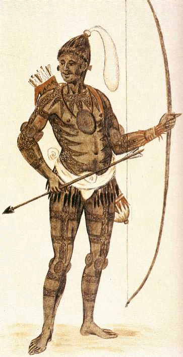
What is now known about Georgia’s late prehistoric chiefdoms makes it clear that these societies, characterized by hereditary chieftains (both male and female, inherited through the mother’s line) maintained at public cost by tributary labor and goods (including the construction of immense earthen platform mounds at multi-generational administrative centers), were significantly different in structure and function from later tribes and confederacies of the later colonial and early American periods. Although the Creek and Cherokee Indians of early 19th-century Georgia were the direct genealogical descendants of the inhabitants of the state’s prehistoric chiefdoms, their political organization was far more egalitarian in nature, lacking the strongly-centralized and strictly-hereditary leadership offices of these ancestral chiefdoms. In a tumultuous colonial era marked by rampant demographic collapse and the contraction of entire chiefdoms into single villages, the formation of new societies from the aggregated remnants of many diverse chiefdoms (many of which were relocated refugees from early English slaving) took into account the presence of many chiefly heirs with equally-valid hereditary leadership claims. Perhaps in part for this reason, tribal political organization depended less upon ancestry and more on individual merit, wisdom, age, and communal respect.
The brief table below lists some of the more commonly-known Indian groups that lived in Georgia at various points during the early colonial period (most immediately prior to 1733), indicating which groups were indigenous, immigrant, or a combination of both, along with notes regarding the origin of each. Below this table is a longer listing of the documented names of indigenous villages in Georgia at the moment of European contact.
| GROUP NAME | STATUS | ORIGINS |
| Cherokee | indigenous/immigrant | Descendants of prehistoric chiefdoms associated with platform mound and village sites distributed in the highest river valleys of the northeastern Georgia Blue Ridge region; expanded into northwestern Ridge and Valley region during the 18th century, including some refugee towns from northwestern South Carolina. |
| Creek | indigenous/immigrant | Descendants of prehistoric chiefdoms associated with platform mound and village sites distributed across central, western, and northwestern Georgia (Ridge and Valley, Piedmont, and Coastal Plain regions); some towns immigrated from Alabama, Tennessee, and elsewhere prior to the crystallization of the broader Creek confederacy during the 18th century. |
| Savannah | immigrant | Small immigrant Shawnee band who replaced the Westo as slave-raiders after 1681 along the Savannah River; some later relocated among the Creek, while others moved north. |
| Timucua | indigenous | Descendants of prehistoric chiefdoms associated with burial mound and village sites distributed across the coastline and interior of the southeastern Georgia Coastal Plain; all were missionized by the 1630s, and all had been withdrawn southward by 1685, where they became extinct by the 1760s. |
| Westo | immigrant | Small imigrant band of Erie Indians who hunted slaves for Virginia and Carolina from their Savannah River base between ca. 1659 and 1681; later fused with the lower towns of the emergent Creek confederacy. |
| Yamassee | indigenous/immigrant | Confederacy of refugee towns that crystallized along the lower South Carolina coast by the early 1660s in response to Westo slave-raiding; several Muskogee-speaking towns (Altamaha, Ocute, Ospo, etc.) were descendants of prehistoric chiefdoms and towns originally situated in the Georgia interior and coast; the Yamassees occasionally allied with the Creeks, but remained politically separate, and most left with the Spanish in 1763. |
| Yuchi | immigrant | Immigrant group from the Appalachian highlands (Tennessee/North Carolina area ?) that settled along the Savannah River after the 1715 Yamassee War, but who eventually attached themselves to the Creek confederacy, nonetheless maintaining strict ethnic and linguistic separation. |
Given the above information regarding the three primary groups indigenous to late prehistoric Georgia, the following table lists the recorded names of individual communities known or suspected to have been present in Georgia at the time of first European contact during the 16th and early 17th centuries.
Along with their chiefly political association and geographic location, the table also specifies the language group of these communities and chiefdoms, with Muskogee in blue, Timucua in red, and Cherokee ingreen. As is obvious from the list (illustrated in the map to the left), at the time of 16th-century European contact, Georgia was dominated primarily by Muskogee-speakers, extending across all but the southeastern Coastal Plain, home to Georgia’s second most populous group, the Timucua-speakers, as well as the highest valleys of the Appalachian Blue Ridge province, which were home to Georgia’s third most populous group, the Cherokee-speakers. By the end of the 18th-century, of course, the Timucuan language was no longer spoken in Georgia (their people would be extinct by 1769), and the Cherokees had spread across much of northern Georgia, including many valleys formerly occupied by Muskogee-speakers.
It should be noted that I have only included one of the names (Hitchiti) of the many villages of the 17th-century Apalachicola province of the lower Chattahoochee River, which was first contacted by Spaniards in the late 1630s, and which later formed the core of the Lower Creek subdivision of the broader Creek confederacy. The primary reason is that maps and other evidence suggest that most of these villages were actually located across the river in present-day Alabama. In addition, very recent archaeological evidence seems to confirm documentary evidence from the 16th-century expeditions of Hernando de Soto and Juan Pardo that several of these villages was originally located along the Coosa River in eastern Alabama, Tennessee, or elsewhere, and had immigrated into Georgia during the late 16th century. While there definitely was an indigenous prehistoric chiefdom along the lower Chattahoochee, its name is not known with absolute certainty, and many or most of its inhabitants appear to have migrated south into northwestern Florida (the Apalachee province) soon after the De Soto expedition, probably in response to the same diseases that seem to have wiped out most of middle Georgia. In most cases, therefore, the ancestral towns of the Lower Creeks appear not to have been directly indigenous to the present boundaries of the state of Georgia, and only moved fully within the state (to the Ocmulgee, Oconee, and Savannah Rivers) after 1691 in response to Spanish pressure.
|
[…] [Indigenous Chiefdoms of Georgia] [European Exploration of Georgia] [English Conquest of Georgia] [Dawn of Oglethorpe's Georgia] [Spanish Archival Sources] [Colonial Spanish Paleography] [FAQ] […]